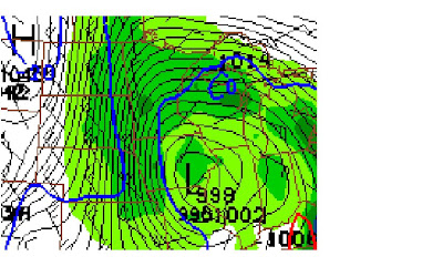
Snow showers starting to push through the state, these will actually start on Tuesday night according to this model. See those black lines around the "L" - those are lines of constant pressure, the more you see really close to the low ("L") mean that that area of low pressure is strong and tells us that this storm will be a potent one. The tighter packed those lines are also tells us that strong winds will accompany this system. Here's a look at what this storm looks like on Thursday around noon:
See how many more lines of constant pressure there are surrounding this system? I added the wind barbs onto this map - you can see this model is estimating wind speeds 20-30 knots, which means we could see wind speeds 25-35 miles per hour sustained with this system. Add in how much snow this model is hinting at and we could see near whiteout conditions on Christmas Eve afternoon. Not the best for holiday travel plans, especially heading to Minnesota (like me - if this pans out, I may have to postpone - suggest you start thinking about rearranging your holiday plans accordingly as well) because you'll be moving right with the storm, if you head West, you'll be driving right into those wicked winds, so either way, looks like a bothersome storm. By Christmas Day, that system looks to be sticking around still:
Things will then push off towards the east and we'll just see a few light snow showers linger in the morning followed by clearing that afternoon. It'll probably be best to keep your holiday travel plans closer to the weekend because we'll just be left with clear skies and cooler temperatures.
This is just one model and it's the most potent model to show this storm at this point, I just wanted to let you know how bad things look right now for Christmas - this model does have a tendency to overestimate precipitation. Keep checking in, we'll let you know how things are going to pan out.
~KDLT Meteorologist Jesse Ritka


No comments:
Post a Comment
Thoughts from you guys...