

 These first two images are looking at sea level pressure and 6 hour precipitation. The first image is when we start to see the main snow event enter our area, at noon on Wednesday. Then by 6 PM we start to see heavier snow move in throughout the southeast regions of the viewing area. If we add these two images together to get total snowfall by 6 pm Wednesday at a 10:1 ratio we would have about 1.5 inches of snow on the ground.


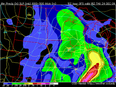
These two images are for the next 12 hours (Thursday at midnight and 6 am). You can see that the system is still pumping snow in our area and that snow could be heavy at times, especially overnight. Accumulated snowfall for this time period we would see about 2 to 3 more inches.
 Thursday at noon most of the snow will move well off to our east and we would see light snow showers until Christmas morning. Total accumulation from the system looks to be around 6 inches but this depends on the snow to liquid ratio. At 10:1 according to this model we would see roughly 4 to 5 inches. The ratio seems to be a little more at this point so my forecast is sitting at 6 inches. Stayed tuned to Jesse's and Cody's forecast for the latest updates on our Christmas system.
~KDLT Meteorologist Dan Bronis
No comments:
Post a Comment
Thoughts from you guys...