 We'll be watching - and make sure you send us your rainfall totals and any pictures you snap to weather@kdlt.com.
Have a good night!
~KDLT Chief Meteorologist Aaron Shaffer
 We'll be watching - and make sure you send us your rainfall totals and any pictures you snap to weather@kdlt.com.
So - with all of that being said - make sure you bundle up and get your rain gear ready. You can see it won't rain *constantly* - but a good chunk of the day will consist of rain vs. no rain.
Have a good night!
~KDLT Chief Meteorologist Aaron Shaffer
 Thursday Afternoon:
 Friday Morning:
 Looks like all areas will see a couple different rounds of rainfall with this system. But its not only the rain but the winds will be a bit of an issue as well. High wind watches and warnings have already been issued for areas from Winner and Mission westward to the Black Hills.
  Winds could gust over 65mph. Not quite as windy out in eastern South Dakota, expecting winds from 10-25mph. But with temperatures struggling to get out of the 40's at times, it will be a chilly and raw couple of days.
Not overly impressive, but remember that is only an estimate and only goes through the first half of the storm system. We'll have more on that system tomorrow.
Have a good night!
~KDLT Chief Meteorologist Aaron Shaffer
 A nice but cool day is expected tomorrow but it does look like a big storm is brewing for later in the week. This storm will likely make its entrance overnight Wednesday and stay around for a couple of days. The Hydrological Prediction Center posted this forecast for Thursday morning through Saturday morning.
  The image below shows that many areas of South Dakota can expect 2+ inches of rain in that time period. So enjoy the sunshine while it's here because the end of the week looks to be quite wet.
 (I grabbed this picture from his blog - Thanks JG if you're reading!)
Not a bad day out there at all this Saturday. In between noon and sunset you can see some middle 70s to the East and lower 80s to the West. Again - no wind to be concerned about toward the East at all, look at this map showing future winds starting Friday night:

You see how the arrows are all tiny & hard to see? That is the sign of good amounts of wind - nearly none. Watch what happens when we get to Sunday night at around 7pm...
 Quite a change, eh? Well by Sunday late afternoon we are looking for winds around 20-30mph sustained around the area, so get ready to hang on to your hat! We cool down significantly to start out the week on Monday as well.
While things may not pan out *exactly* as this movie would indicate - something close to that really wouldn't be a stretch. You can see showers moving in Friday morning and then moving out by Friday night.
The clearing shows up by Saturday late morning to early afternoon. Look at the possible temperatures as a result as well:
 See those middle 70s? Those could be what we see for Saturday's highs assuming that clearing moves in fast enough.
Here's to that!
~KDLT Chief Meteorologist Aaron Shaffer
 Even though these winds are a good 4000-5000 feet above the surface, with the potential for really good mixing occurring on Sunday, these winds could find their way down to the surface. This means that we could be dealing with 50+ mph gusts at the surface.
If you watch KDLT with any regularity, especially over the past week or so, you've probably noticed we've had some "friends" on our KDLT Skycam recently. Last week, it was the wasps - and this week it is a much more pleasant species: birds.
You can see we had about a minute worth of fun with these guys - with thick clouds as the backdrop. Big changes sky condition-wise from what we saw earlier in the day with some sunshine.
 Thursday Morning:
 Friday Morning:
 Saturday Morning:
Once that low pressure swings out of our area, abundant sunshine will return. But things don't look all that warm as another cold front looks to make its way in by Monday that has the potential to give areas of South Dakota its first frost. We will keep you updated as we get closer.
~KDLT Meteorologist Cody Matz
 But these clouds that are blocking out the sun and keeping away the warmer temperatures are also acting like a blanket for us at night and making sure our temperatures don't drop below 40 degrees . . . good news for all the farmers and folks with gardens out there.
You can see all of the green shaded areas basically showing the best chances for accumulating rainfall. You'll likely see that pocket of no rainfall in eastern SD get filled in a little bit, while the brighter green areas will likely be tempered a bit. Also - you are probably wondering what the deal is with the cold temperatures... If you didn't watch us on KDLT on Friday night, you would have missed our video of where the jetstream is/will be. Look at this one to see what is actually happening outside:
Take a moment and check out our blog post showing the jetstream from Friday night - and compare to now. Big changes out there - and that pocket showing up right over our area is a cold dip in the jetstream... we don't kick that out for a couple of days, so stay tuned!
~KDLT Chief Meteorologist Aaron Shaffer

You can also see there are some rather strong northwesterly winds that will only make things feel cooler outdoors. We've been spoiled with the southerly winds keeping our temperatures above average but the reality is that Fall officially begins on Tuesday, and there's no doubt that it will feel like it.
If you miss the 70s, just hold on until Wednesday when the 70s and sunshine return!
~KDLT Meteorologist Jesse Ritka

Keep in mind, that's just one particular model...
I'm personally kind of sad that it'll be so nice tomorrow since it is such a big NFL day. It's my first time ever playing in a fantasy football league (playing with people at KDLT), and tomorrow's a big day since my team is playing against Aaron Shaffer and he has Adrian Peterson . . . I'm a bit nervous. I'm just going to put our matchup on here, feel free to predict who you think will win between the two of us, I think that'll be fun to see. 
In case you were wondering . . . my team is "GolfBallSizeHailMary" . . . nerd? Yes, I know :)
Enjoy the rest of the weekend!
~KDLT Meteorologist Jesse Ritka
We've been talking a lot about the storm on the way this coming Sunday night to Monday morning. We made a special graphic for the blog - and check it out:
If you look closely you can see some lines that line up with the rotating "L" (low pressure system symbol). It doesn't look like it's in a hurry to go anywhere. In fact, it looks like we will see what is known as a "cut-off low" form.
The other big change will be temperature-wise. Over the past 6 days we've seen the jetstream centered over central Canada - leaving us nice and warm. It's going to change soon - check out this video below:
We'll still stay warm through Sunday - but cooler air will creep in behind that dip in the jetstream at the end of that video clip.
Enjoy this weekend's warmth, but don't get caught off guard by the breezy conditions!
~KDLT Chief Meteorologist Aaron Shaffer
 It's been 0.2 degrees warmer so far these last 8 days than what is typically our 2nd warmest month of the year. Hopefully we can keep it up while we wait for that next cooldown to come in. We'll be talking much more about *that* over the next few days!
Have a good night!
~KDLT Chief Meteorologist Aaron Shaffer
 So enjoy the summer like weather because it looks like fall will start with bang.
 See all of those lines? Those are different "thicknesses" in the atmosphere that indicate regions of freezing or cooler temperatures. That's what we look at when forecasting snow... and they are over eastern South Dakota and Minnesota and even into northern Iowa by next Wednesday. That could mean some possible flurries by Wednesday - but don't worry, averages and records are on your side if you want snow to stay away.
Snow fell from the early morning to the late evening hours across northwest South Dakota bringing more than a foot of snow to some locations. Camp Crook in Harding County reported 14 inches. Amounts between six and twelve inches were common across Harding and Perkins Counties as well as parts of Meade and Butte counties. Roads in these areas were slushy with icy bridges. The snow covered much of the western third of South Dakota with depths generally an inch or less.
 The jet stream on Friday:
 But one of the long range models does have this ridge breaking down by Monday which could bring our first taste of fall air into the region.
 This is something we will have to watch through the week and we will keep you updated.
 We're almost 5 inches below average - and this is without much, if any, rainfall in the forecast over the next few days. On average we should be adding about 0.09" of rainfall per day - so we'll be likely adding over half an inch of rain to the deficit by the start of next week.
The good news for people who don't want rain, and not for anyone needing rain, is that things are looking warmer for the start of this week. Check out a screenshot from our Futurecast computer model:
 Warmer weather sticks around - and that cold front you see drawn on that map represents our best chance for some showers toward mid to late-week.
Have a nice evening!
~KDLT Chief Meteorologist Aaron Shaffer
 I realize that sounds weird since our weather typically moves from west to east but this low is cutoff from the jet stream (the river of air high up in the atmosphere that controls where storms will move) and that is causing this low pressure to move in any direction it wants. Well its finally going to move out of our area for the latter half of your Sunday. When that happens, southerly winds will kick in and our temperatures look to remain above average most of next week. You can see the warm up on the 850mb charts below.
  Monday:
 Tuesday:
 So looks like fall temperatures are going to hold off for at least a few more days. Enjoy!!
 Sunshine during this massive storm system? That's right. It's because of something we call a "dry slot" and it happens quite often in these parts. They make what would otherwise be the right forecast slightly off - and are predictable only in that they will form.
A quick peek at the National Weather Service's glossary reveals this definition:
Dry Slot
A zone of dry (and relatively cloud-free) air which wraps east- or
northeastward into the southern and eastern parts of a synoptic scale or
mesoscale low pressure system. A dry slot generally is seen best on satellite
photographs.
So there you go - and that dry slot will be shifting slightly south and west over the next 24 hours as this strong, but disorganized, system moves to the West.
Check back on the weather blog over the weekend to find out more about this system!
~KDLT Chief Meteorologist Aaron Shaffer

You can see the rain overhead Friday night - and that is after a few little batches throughout the day. Look at this map showing temperatures, then, for Saturday night:
 We tightened up the temperature scale on here to make the changes in temperature more obvious - and you can see in the area some big contrasts from our viewing area to the Minneapolis-area and western Wisconsin.
Right now we're still looking for lower 70s for the most part on Saturday - and some areas struggling to reach the upper 60s farther toward the West.
Have a good night!
~KDLT Chief Meteorologist Aaron Shaffer
 Now look at today's forecast model. It has the position of the low Saturday evening a bit further to the west.
  Some adjustments may still have to be made in the forecast because of this unique situation so just check back with us before the weekend and we should know some more information.
 You can see in that screenshot of a map we just showed on-air that by Friday night our Futurecast computer model has rain and a cold front right over us. We'll look for showers to actually start early on in the day toward the West - with those showers fairly speedily moving farther toward the East by the afternoon.
Then we get 60s & 70s again for highs this weekend. We'll leave that for another post and wish you a good night!
~KDLT Chief Meteorologist Aaron Shaffer

You can see it was near south-central South Dakota - and moving slowly. Here is our future radar from about now until 7:15pm - it will be interesting to see where it ends up and just how closely reality matches our future radar:
 Still far away from Sioux Falls by 7:15pm - but it'll come eventually by the overnight hours toward the far southeast.
Have a good night!
~KDLT Chief Meteorologist Aaron Shaffer
 With the heavy rain could be some severe weather as well, something we haven't talked much about over the last few weeks. The Storm Prediction Center did issue a slight risk for severe weather over much of eastern South Dakota and parts of far western Minnesota. I'm not expecting a widespread outbreak but don't be surprised to see a few warnings that may pop up later today and tonight for some large hail and damaging winds.
  ~KDLT Meteorologist Cody Matz
You can see the showers there by 12:30am - at least according to our new Futurecast computer model. Add or subtract an hour or two from that time, and that is about when you can expect showers and thunderstorms. It seems as though this storm system will slow down and leave us with some decent amounts of accumulations:

That up to 1 inch mark is basically centered around the Mitchell area - but has the potential to shift around a little bit. In general we are looking for most people to pick up around a quarter of an inch, with locally heavier areas picking up closer to 1" of rainfall.
Then we have the chilly weekend. You saw some first glimpses of the cooler air overhead for the weekend in Cody's post below, but look at this image showing possible morning lows for this weekend:

Middle 40s are becoming a little bit too common, but that is a sign of things to come - unfortunately. Our average overnight low for southeastern South Dakota dropped to 51 today, and will continue to drop for a while.
Enjoy the rest of your Labor Day holiday and have a good rest of your week!
~KDLT Chief Meteorologist Aaron Shaffer
 This will also begin to increase moisture later on today as well with dew points getting into the 60's in spots. This will actually aid in our thunderstorm chances tomorrow and tomorrow night.
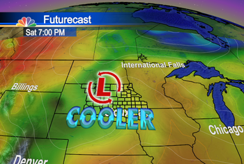
 Now, I realize that many of us are still on our holiday weekends but I wanted to focus a second on the forecast for next weekend because it's looking more and more intriguing. All of the long range models show a pretty intense low pressure diving into the upper Midwest Friday into Saturday which will likely bring unseasonably cool weather to our area. Notice the "bubble" of cold air over the state of South Dakota on Saturday.
 This is just one of the long range models but all of them are in astonishing agreement over this trough digging in next weekend. If this forecast holds and if we end up seeing a good deal of cloud cover, some areas may only see highs in the 50's this weekend. So stay tuned through out the week and we will keep you updated!!