
First off, I would like to say thank you to those of you who follow our blog on at least a semi regular basis. We are able to keep the blog going because of you!! However, we have a new website and we are going to continue this blog on there. With the new site there is more information, content, and space to provide you with news, weather, and sports. It's like a completely different country compared to our old site. It is very simple and easy to navigate so I think the other station's sites pale in comparison. We will be trying to transfer some of our most recent posts over to the new blog so you guys can reference some of our old posts, but give us a few days cause it takes a while. Other then that, this will be the last post on the blogger site. So delete this bookmark and add our new weather blog. Here is the link; KDLT WEATHER BLOG. Thanks again for watching and reading. If you have any questions or comments, it has never been easier to contact us. Just go to the "Contact KDLT" tab at the top of any page at our website and you can ask or say anything you want. Enjoy the new site!!
~KDLT Meteorologist Cody Matz
Friday, January 29, 2010
Thursday, January 28, 2010
The Weather-people are Always Wrong...Maybe Not Always
I'm not the first to admit that we can be wrong when we tell you the forecast on air. But keep in mind while many science fields there is a right and a wrong way of doing things, with weather, forecasting is nowhere near an exact science, and thus we will not always be 100% accurate on the forecast. One of the main reasons we can be a bit off on the forecast is because we don't have an accurate idea of what's going on across the entire atmosphere to begin with. We take current observations and current data in account when we are forecasting, if the current data is wrong, we can't accurately tell where storm systems will move. So if everyone on the Earth would take weather data and send it into a huge supercomputer, we'd have a much better idea of a starting point. 
"The highly specialized twin turbofan jet will be stationed at Yokota Air Force Base in Japan through February before repositioning to Honolulu in March. From these locations, the aircraft will be tasked by the National Centers for Environmental Prediction — a division of NOAA’s National Weather Service — to fly into data sparse regions to collect information such as wind speed and direction, pressure, temperature and humidity. This data will be sent via satellite to global operational weather forecasting centers — and fed into sophisticated computer forecast models.
“These flights will help us better observe and understand the current state of the atmosphere over the Pacific, where most of North America’s weather originates, in order to better predict future conditions across the U.S. and Canada three to six days in advance,” said Louis Uccellini, Ph.D., director of the National Centers for Environmental Prediction in Camp Springs, Md.
These computer model improvements will play an essential role in meteorological support for the Winter Olympics in Vancouver in addition to more precise precipitation forecasts along the U.S. West Coast and points further east.
NOAA incorporated the Japan-based missions into its annual Winter Storms Reconnaissance program in early 2009 — flying 332 flight hours and logging miles equivalent to circling the Earth five times. Prior to 2009, missions were flown from Alaska, Hawaii and the U.S. West Coast. By expanding the reach across the International Date Line to Japan, NOAA is essentially pushing farther upstream to observe areas of interest with greater lead times.
These missions showed significant positive impact to global numerical weather prediction models, increasing both accuracy and lead times for high-impact weather events. For example, model forecasts of precipitation amounts improved, on average, 10 to 15 percent.
The high altitude, high speed NOAA Gulfstream IV is based at the NOAA Aircraft Operations Center, located at MacDill Air Force Base in Tampa, Fla.NOAA understands and predicts changes in the Earth's environment, from the depths of the ocean to the surface of the sun, and conserves and manages our coastal and marine resources. "
I like to compare it to directions - if someone gives you directions to a location, it's easy to get there, but if they give you directions from an unknown starting location, how are you going to get there? So the more accurate of a starting location you have, the easier it is to get to where you are going. Same story with weather, the more accurate of a starting location (or state of the atmosphere/surface & upper air observations) the more accurate of a forecast we will have. But even if we were to have everyone on Earth send in all this starting weather data, we still would be completely in the dark with systems coming in from the oceans.
That's changing however. Currently there are several ways to take observations out at sea, many of them being with weather buoys. The National Data Buoy Center has several of these planted all around the world to take current observations at the surface, so we can get a a better idea of what kind of systems are going to be moving onshore.
  Their website is extremely interactive, you can click on any of the buoys for the information.
 As you can tell, there are several areas where there are no buoys, and thus no data. The big change in ocean observations is coming via jet. Here's a look at NOAA’s Gulfstream IV aircraft. This jet is known best for taking weather observations in Atlantic hurricanes, but now it's going to be taking weather observations over the Pacific Ocean to help improve winter storm forecasts.
 (Credit: NOAA)
The National Data Buoy Center has several of these planted all around the world to take current observations at the surface, so we can get a a better idea of what kind of systems are going to be moving onshore. Their website is extremely interactive, you can click on any of the buoys for the information. As you can tell, there are several areas where there are no buoys, and thus no data. The big change in ocean observations is coming via jet. Here's a look at NOAA’s Gulfstream IV aircraft. This jet is known best for taking weather observations in Atlantic hurricanes, but now it's going to be taking weather observations over the Pacific Ocean to help improve winter storm forecasts.(Credit: NOAA)Here's what the National Oceanic and Atmospheric Administration says about this new addition into gathering current conditions:
"The highly specialized twin turbofan jet will be stationed at Yokota Air Force Base in Japan through February before repositioning to Honolulu in March. From these locations, the aircraft will be tasked by the National Centers for Environmental Prediction — a division of NOAA’s National Weather Service — to fly into data sparse regions to collect information such as wind speed and direction, pressure, temperature and humidity. This data will be sent via satellite to global operational weather forecasting centers — and fed into sophisticated computer forecast models.
“These flights will help us better observe and understand the current state of the atmosphere over the Pacific, where most of North America’s weather originates, in order to better predict future conditions across the U.S. and Canada three to six days in advance,” said Louis Uccellini, Ph.D., director of the National Centers for Environmental Prediction in Camp Springs, Md.
These computer model improvements will play an essential role in meteorological support for the Winter Olympics in Vancouver in addition to more precise precipitation forecasts along the U.S. West Coast and points further east.
NOAA incorporated the Japan-based missions into its annual Winter Storms Reconnaissance program in early 2009 — flying 332 flight hours and logging miles equivalent to circling the Earth five times. Prior to 2009, missions were flown from Alaska, Hawaii and the U.S. West Coast. By expanding the reach across the International Date Line to Japan, NOAA is essentially pushing farther upstream to observe areas of interest with greater lead times.
These missions showed significant positive impact to global numerical weather prediction models, increasing both accuracy and lead times for high-impact weather events. For example, model forecasts of precipitation amounts improved, on average, 10 to 15 percent.
The high altitude, high speed NOAA Gulfstream IV is based at the NOAA Aircraft Operations Center, located at MacDill Air Force Base in Tampa, Fla.NOAA understands and predicts changes in the Earth's environment, from the depths of the ocean to the surface of the sun, and conserves and manages our coastal and marine resources. "
So hopefully we'll get a little better at forecasting those winter storms further out in the forecast.
Keep warm today!
~KDLT Meteorologist Jesse Ritka
Wednesday, January 27, 2010
Coldy is Back!
The bitter cold has returned to the area like I told you it would yesterday. Wind chill advisories are posted for much of the east for wind chills 15 to 30 degrees below zero overnight tonight and into Thursday morning. Good news for Thursday though as the winds will settle down and we will see lots of sunshine. But highs are going to struggle, staying in the single digits and low teens.
Good news for Thursday though as the winds will settle down and we will see lots of sunshine. But highs are going to struggle, staying in the single digits and low teens.As for the title of this posting, those of you that watched the 6pm newscast a few weeks ago, Jessica stumbled as she was saying my name and it came out as coldy. Now this was appropriate at the time because it was extremely cold. But now every time it's going to be cold outside, everyone calls me coldy. It's amazing the things that catch on! Stay warm!!
~KDLT Meteorologist Cody (Coldy) Matz
Tuesday, January 26, 2010
Staying Cold
We are finally rid of another storm and it actually looks like we have some dry weather ahead, at least for a little while. We are slipping into a drier and colder pattern for the next few days. The good news with that, we will see lots of sunshine. The bad news for those of you looking to shed your heavy winter coat, is that temperatures look to stay quite chilly through at least the end of the week. Here is a look at temperatures at the 850mb level tomorrow afternoon and Thursday afternoon.
 Remember that these temperatures are about 5000 feet in the air. But this gives us a good look at just how cold the surface will be. It is going to be breezy on Wednesday, but that will help temperatures stay a bit warmer because mixing helps warm the atmosphere. But Thursday looks calmer and colder with highs some 20 degrees below average.
 Probability of seeing precipitation above or below average 8-14 days from today:
 Looks like that temperatures and precipitation will be near normal overall in that time frame. The good news is they (CPC) are not seeing any major storm systems moving through our area in the next 14 days. However, that can change so just keep your fingers crossed and maybe we can get through the next few weeks with no major weather makers.
Remember that these temperatures are about 5000 feet in the air. But this gives us a good look at just how cold the surface will be. It is going to be breezy on Wednesday, but that will help temperatures stay a bit warmer because mixing helps warm the atmosphere. But Thursday looks calmer and colder with highs some 20 degrees below average. In case you are wondering what is in store for us after the next 7 days, here's a preview. The Climate Prediction Center issues forecast for probabilities of being above or below average in temperature and precipitation. Here they are;
Probability of seeing temperatures above or below average 8-14 days from today:
Probability of seeing precipitation above or below average 8-14 days from today:Looks like that temperatures and precipitation will be near normal overall in that time frame. The good news is they (CPC) are not seeing any major storm systems moving through our area in the next 14 days. However, that can change so just keep your fingers crossed and maybe we can get through the next few weeks with no major weather makers.~KDLT Meteorologist Cody Matz
Interstates Opening
I-90 is now open state-wide, and I-29 is open from the southern border to Brookings, I-29 remains closed at this moment from Brookings to the North Dakota border. Here's a look at why:  But crews are out trying to clear the roads... you can see that 2 hours later (at 7:20 when this picture was captured on the same camera) the drift is gone and there's just a bit of water left where the snow drift was.
 Keep tuned onto KDLT, we'll update the closings ticker on the bottom of the screen throughout the day with more updates about the interstates.
This picture was captured on the DOT street cameras (accessed through www.safetravelusa.com/sd) around 5:20 this morning. I circled the snow drift that takes up most of the road.
But crews are out trying to clear the roads... you can see that 2 hours later (at 7:20 when this picture was captured on the same camera) the drift is gone and there's just a bit of water left where the snow drift was.Keep tuned onto KDLT, we'll update the closings ticker on the bottom of the screen throughout the day with more updates about the interstates.Stay safe on the roads, winds will be diminishing today, so enjoy some more mild weather this week... just bundle up since it will be colder than normal.
~KDLT Meteorologist Jesse Ritka
Monday, January 25, 2010
Blizzard Today
The fourth blizzard this season is making its way through the region and causing some big problems for travelers as white out and near white out conditions could be found all across the region. Here are just a few pictures from this storm.


 Roads are nearly impassable in many spots because of blowing snow and drifting. Here are the current road conditions.
 No travel is advised East of the Orange dashed line so just sit tight wherever you are and wait till morning to venture out.
Roads are nearly impassable in many spots because of blowing snow and drifting. Here are the current road conditions.No travel is advised East of the Orange dashed line so just sit tight wherever you are and wait till morning to venture out.~KDLT Meteorologist Cody Matz
A Blustery, Blustery Day
We've still got snow showers left over this morning from the weekend storm system, they are still wrapping around the area of low pressure that has moved off to our east, so expect these snow showers to follow suit and decrease from west to east this afternoon. The winds are going to cause wicked problems today. They will be strongest this morning and into the afternoon hours, gusting up to 50mph. This will cause the falling snow to blow around, reducing visibilities. Here's a brief breakdown of your wind forecast: Things will taper off a little later this evening, but the windy conditions will continue to cause blowing snow and reduce visibilities.
 The winds will die down by Tuesday afternoon and the snow will have stopped by then, so we're looking at a more calm forecast from then on.
 These winds are all from the northwest, so naturally they will bring colder weather into the forecast. Expect single digits near zero, some folks in the northeast may dip below zero tonight, which will set the stage for a colder work week.
Things will taper off a little later this evening, but the windy conditions will continue to cause blowing snow and reduce visibilities. The winds will die down by Tuesday afternoon and the snow will have stopped by then, so we're looking at a more calm forecast from then on.
 These winds are all from the northwest, so naturally they will bring colder weather into the forecast. Expect single digits near zero, some folks in the northeast may dip below zero tonight, which will set the stage for a colder work week.
Bundle up,
~KDLT Meteorologist Jesse Ritka
Sunday, January 24, 2010
Winds of Change, Really...
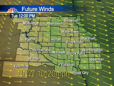
If you haven't stepped outside that should of not stopped you from noticing how windy its been lately. We have sustain winds near 40 mph in some locals, and gusts over 50 mph! With the snow that's falling and the fresh snow covering the ground, those winds sure make it seem like blizzard conditions out there. There are no blizzard warnings out for any areas, only wind advisories. These winds will plague the area till Monday evening, when we notice calmer breezes for Tuesday. As of Sunday evening here's what the sustained winds looked like:
 Here's the strong Wind gusts:
 What we can expect to see Monday morning when the winds should be at their strongest. This is when gusts can exceed 50 mph in all locations.

 These winds are bringing in much cooler air also, highs in the teens for Tuesday and Wednesday, but that will seem warm compared to what we can expect for Thursday! Stay warm and enjoy this cold week coming up (the sun will seem nice)!
Here's the strong Wind gusts:What we can expect to see Monday morning when the winds should be at their strongest. This is when gusts can exceed 50 mph in all locations. Since the strong winds are forecasted to hang out in South Dakota, the NWS has issued high wind advisories through the night on Sunday and all day Monday, not expiring till Monday at 9pm, but a few counties will expire those advisories at 6pm (mainly up north). All the brown on the map (most of South Dakota) are your high wind advisories.
These winds are bringing in much cooler air also, highs in the teens for Tuesday and Wednesday, but that will seem warm compared to what we can expect for Thursday! Stay warm and enjoy this cold week coming up (the sun will seem nice)!~KDLT Meteorologist Dan Bronis
Saturday, January 23, 2010
Whats Ahead
Friday we started to see rainfall across the area, and some freezing rain up north, near Sisseton and Watertown.
Out towards the west very little rain as this Storm has been an eastern weather maker so far. Mobridge saw less than a tenth inch of rain and Chamberlain is the only town that saw over a quarter inch of rain out towards the west. Some totals were actually very impressive: Sioux Falls, Spencer, Watertown and Sisseton were all over three tenths a inch with some freezing rain; Which caused ice to build up on power lines and trees, but no major damage with this storm, a few power outages in some locals.
Snow will start to fall as the low moves off to the east and we see northwest winds pick up in the area. Light snow fall is expected with the extreme north seeing the most snowfall, four inches tops. Winds will be the main problem in all areas, sustain winds easily topping 40 mph and gusts over 55 possible.
The strongest winds will occur Monday morning but the winds will start Sunday morning and last till Tuesday morning. This model picks up on the strong winds but I do believe they will be stronger then what this shows. Blowing snow will cause low visibilities, and the high winds/ice on the roads can cause cars to slide off and create accidents. Use caution and be prepared!
Were not done yet with this storm, come Tuesday we can see sunny skies and calmer winds. But temperatures will not be very pleasant, highs in the teens for Tuesday and Wednesday.
~KDLT Meteorologist Dan Bronis
Friday, January 22, 2010
The Weekender
Wanting to know what, where, and when we will see all different kinds of precipitation?? Here's your answer!

 Here is an updated version of the expected snow and ice accumulations.
 The temperatures at 5000 feet this evening are well over freezing. In fact, they are in the upper 40's in some spots. That is what melts the snowflakes and causes our freezing rain. Stay safe out there!!
Here is an updated version of the expected snow and ice accumulations.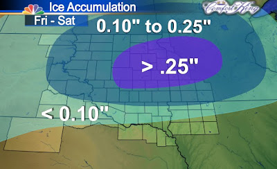 So why are we seeing so much rain and freezing rain?? Well here's that answer. Temperatures and moisture have to be just right to form snowflakes. Its actually a very complicated process and they don't come from rain droplets freezing. That's sleet or in the summer time its hail. But when you have snow that develops and starts falling through the atmosphere, the entire column of air that the flake travels through must be below freezing for the flake to reach the ground. Well, when you have air that's about 45 degrees, for example, at 5000 feet, then the flake is going to melt into a raindrop. It will then continue to fall through the atmosphere as a raindrop all the way down to the surface. Well, if the surface happens to be below freezing, then that's when you get freezing rain. If you look at the picture below, of the temperatures at 5000 feet, you should notice something pretty quickly.
The temperatures at 5000 feet this evening are well over freezing. In fact, they are in the upper 40's in some spots. That is what melts the snowflakes and causes our freezing rain. Stay safe out there!!~KDLT Meteorologist Cody Matz
Weekend Update
The major storm that has affected the southwestern United States this past week has finally moved inland and will start to effect our weather with snow, sleet, rain and ice. The past 24 hours we've seen a freezing drizzle, but with the surface low moving into our area, that will slowly switch over to a freezing rain/sleet.
Here's a radar image of the little activity seen across the region this morning:

Here's a radar image of the little activity seen across the region this morning:
There was a little mixed precip located near the South Dakota border and Nebraska, that should start to build up over the next few hours and effect the central portions of the state (Pierre, Mobridge, Aberdeen) with freezing rain and snow, by the mid afternoon hours. The eastern portion of South Dakota won't see much activity until the later afternoon hours and most of that will be rain/freezing rain with temperatures near freezing.
Friday night into Saturday will be the main threat for freezing rain. Accumulations can be expected with a half an inch tops in some locations. That will switch over to snow by Saturday night into Sunday. Be careful on the roads and stay in if it is not a necessity to leave, it will be dangerous with ice build up expected.
~KDLT Meteorologist Dan Bronis
Thursday, January 21, 2010
Rain in January??
Rain in January is not something you here very often around here. Usually its snow this and snow that. Well, this time of year I think most people wish for the snow because when you get rain, you get pictures like this one.


Areas of freezing rain have been pretty common the last couple of days and this morning Jesse and I decided to de-ice her car. Well, we pulled a couple of large pieces off her car, probably a tenth of inch thick or so, and thought we would take a picture. Yes.....this is what weather nerds do on their free time!
Continuing on the topic of rain and freezing rain, this upcoming storm will probably be one to remember because if the forecasting models play out like they are supposed to, then we could see record January rainfall in some spots. Check out what our futurecast is pumping out for rain and freezing rain across the area. I realize Jesse showed you this same thing earlier but this is a new model run and the figures are even more impressive. Keep in mind that this model does not like to spread out moisture like it should so places like Aberdeen and Mobridge will likely see more then what this shows but this gives you a general idea of how much we are expecting. Now, looks like many places will see just about every precipitation type imaginable. I just showed you the rain, here is what we are expecting for snow and ice.

 So when and where are we going to see all of this happen? Well, I have mentioned before that a picture is worth a thousand words, well this should explain a lot.

Keep in mind that this model does not like to spread out moisture like it should so places like Aberdeen and Mobridge will likely see more then what this shows but this gives you a general idea of how much we are expecting. Now, looks like many places will see just about every precipitation type imaginable. I just showed you the rain, here is what we are expecting for snow and ice.So when and where are we going to see all of this happen? Well, I have mentioned before that a picture is worth a thousand words, well this should explain a lot.I don't think I can show a better explanation than that. That pretty much covers it. Accumulating rain, freezing rain, and sleet Friday night through Saturday. Then accumulating snow Saturday night through Monday morning. Don't forget about those wicked, nasty, ridiculous winds though. Friday through Saturday morning they will be out of the southeast 15-30 mph. Then they will be calmer Saturday afternoon through Sunday morning. But they will begin to howl again on Sunday and Monday out of the northwest some 20-40 mph with gusts to 50. Enjoy!
~KDLT Meteorologist Cody Matz
Weekend Winter Woes
Cody's precipitation map from the last post sums up this upcoming storm pretty well. We're going to see freezing rain and even rain showers in the southeast section of our viewing area because temperatures are going to creep above freezing for Saturday. Here's a look at what Futurecast is showing for rainfall by Saturday afternoon: Keep in mind that part of these totals are rain along with freezing rain, so it's not all going to freeze upon hitting the ground, but when temperatures dip below the freezing mark in the evening and overnight hours, that's when we're going to be worried about re-freezing.
This system will affect the other half of our viewing area as well. But temperatures will stay colder and while this system will bring some freezing rain to the northern half of the state, we will see more snow in those areas from this storm from Saturday and Sunday. Locally, we could see up to a foot of snow in the northwest section of the viewing area and lighter amounts to the south. The reason for lighter amounts down south is because the precip. type in the south, again, is going to be more freezing rain and then changing to snow by Sunday.
Make sure you have a good scraper and shovel for this weekend!
~KDLT Meteorologist Jesse Ritka
Keep in mind that part of these totals are rain along with freezing rain, so it's not all going to freeze upon hitting the ground, but when temperatures dip below the freezing mark in the evening and overnight hours, that's when we're going to be worried about re-freezing.This system will affect the other half of our viewing area as well. But temperatures will stay colder and while this system will bring some freezing rain to the northern half of the state, we will see more snow in those areas from this storm from Saturday and Sunday.
Locally, we could see up to a foot of snow in the northwest section of the viewing area and lighter amounts to the south. The reason for lighter amounts down south is because the precip. type in the south, again, is going to be more freezing rain and then changing to snow by Sunday.Make sure you have a good scraper and shovel for this weekend!
~KDLT Meteorologist Jesse Ritka
Wednesday, January 20, 2010
The Weekend Storm
Areas of freezing rain, sleet, and snow today for many areas, but this storm will seem like a breeze when you compare it to our next one which is set to effect our area this weekend. Winter storm watches are already posted for eastern Montana, almost all of North and South Dakota, and parts of western Minnesota.
 This storm will likely bring all four types of precipitation to the area; rain, freezing rain, sleet, and snow. Now, depending on where you are located will depend on exactly how much of each of these types of precipitation you will receive. Here is what we are expecting to be the predominant hazards with this next storm.
 All told, some areas could end up with a foot of snow while other ares could get a half inch of freezing rain and then a couple inches of snow. Either way, this weekend will be a travel nightmare.
The HPC (Hydrological Prediction Center) are some of the brightest minds when it comes to forecasting what type of precipitation you will have and exactly how much. Here is what they think.
Amount of liquid equivalent precipitation will fall from now through Monday night; Probability of receiving 4 or more inches of snow from 6pm Friday through 6pm Saturday:
 Probability of receiving at least a quarter inch of freezing rain from 6pm Friday through 6pm Saturday;
Probability of receiving 4 or more inches of snow from 6pm Friday through 6pm Saturday:Probability of receiving at least a quarter inch of freezing rain from 6pm Friday through 6pm Saturday; Now keep in mind that the last two images do not include the entire storm. So much more can be expected Saturday night and Sunday as well. If you have travel plans this weekend, I would seriously consider having an alternative plan.
~KDLT Meteorologist Cody Matz
Wintry Mix Arrives
 And boy has it arrived... reports around Sioux City, Iowa have shown 0.4 inches of freezing rain has already accumulated. Sioux Falls saw the freezing rain earlier this morning and now most of the precipitation moving through South Dakota at the moment is falling as snow, with a few areas of sleet being reported as well.
  But the big issue will be the roads this morning since most of the southeast saw freezing rain this morning to put a bit of an ice coat onto the roadways. Covering it up with snow could fake some drivers out, so keep your distance from the car in front of you as slippery conditions are likely going to be a common theme all day today. No travel advisories were posted for much of southeast South Dakota earlier this morning but some of those have been lifted so make sure you check out www.safetravelusa.com/sd or call 511 before you decide to take a longer drive. Ice storm warnings are in effect in extreme southeast SD and into Nebraska and Iowa where the most ice accumulation is occuring.
Be safe on the roads... we'll have more on this weekend's storm, including another shot of freezing rain in future blog postings.
~KDLT Meteorologist Jesse Ritka
Tuesday, January 19, 2010
Caution.... Freezing Rain Ahead
Freezing rain is on its way here. Ice storm warnings and winter weather advisories are now in effect in the southeast.  These go through 9pm Wednesday. Those areas can expect a tenth to a quarter of an inch of ice and an inch or so of snow/sleet accumulation. Other areas could see a little freezing drizzle and then some light snow and sleet.
 ~KDLT Meteorologist Cody Matz
These go through 9pm Wednesday. Those areas can expect a tenth to a quarter of an inch of ice and an inch or so of snow/sleet accumulation. Other areas could see a little freezing drizzle and then some light snow and sleet. We keep talking about it but what exactly is freezing rain. Freezing rain is rain that falls and freezes on contact with anything at the surface. What happens is precipitation falls out of the clouds as snow. But there is a layer of the atmosphere somewhere between the cloud and the surface that is above freezing and melts the snow into rain. Once the precipitation is all rain, it cannot refreeze back to snow so it falls on the surface as rain. It takes very little freezing rain to cause problems from slick roads to power outages. Hopefully we can keep the ice accumulation as low as possible.
~KDLT Meteorologist Cody Matz
Subscribe to:
Comments (Atom)