Saturday, October 31, 2009

A very below normal month - warmer weather ahead!

I don't need to tell ANYONE it's been a below normal month as far as temperatures go. This is just one graph for Sioux Falls (though most of the state looks similar) that shows us where our actual temperatures wound up with respect to where they should be on their respective days. (Courtesy of the NWS in Sioux Falls - check out other cities near SF here or in central and northern SD check here)

The areas in green is where our temperatures SHOULD have been, areas in blue is the range of temperatures showing temperatures below normal getting as cold as the record cold temperature and areas in the red/pink is the range of temperatures up to the record high for that day. The navy blue bars show the low and high temperatures for the day, the top of the bar being the actual high, the bottom of the bar being the actual low. You can definitely see that nearly all of our temperatures stayed in the lower half of the green range - keeping us below average. There were only 2 days where temperatures were above average and 2 days where we hit average.


Good news is on the way if you don't like those cooler temperatures. As we start November, we'll start seeing those warmer than normal temperatures creep back into the forecast. Especially tomorrow - temperatures in the 60s!

And if you look at the 3 month temperature outlook from the climate prediction center... we'll keep that above normal trend around all the way through January! Of course if you're a big snow fan - you'll have to wait a bit longer for any snow we see to stick because this winter won't be as cold, so snow will melt a lot faster in the beginning of the winter season.

Enjoy the warmer temperatures for now though!

~KDLT Meteorologist Jesse Ritka

Friday, October 30, 2009

Not a Scary Looking Forecast

Good news for everyone that doesn't like precipitation!! Looks like we may have a stretch of tranquil weather for most of this week. Not only tranquil but temperatures will likely be at or even slightly above average which would seem to be something new to us. The reason for the tranquility is that we seem to be going into a more zonal flow. What that means is that the jet stream, for the most part, is traveled west to east on a pretty straight line. The jet stream is the river of air at the top of the atmosphere that controls where weather systems, high pressure and low pressure, go and also has a big influence on temperature.

So how this works in the most basic of terms is that when there are giant kinks in the jet stream like you see in the very first picture below, you will typically have cold air competing with warm air which will create some sort of weather system which will create precipitation. But with no kinks in the jet stream, then cold air stays toward the poles and warm air stays toward the equator and most of the U.S. has generally quiet weather.

This is the jet stream over the next five afternoons starting with Friday. Notice that the jet stream starts with a kink in it (major storm) and then transitions into a straight line (zonal flow).
I hope everyone will enjoy the nicer weather and the sunshine. I love the rain and snow but it will definitely be nice to see the sun for a few days.
~KDLT Meteorologist Cody Matz


Boo x 2!

Well the first boo is for the wind and rain, farmers do not need all this rain right now - we've already seen a half inch up to an inch and a half in places just from yesterday and last night's rain and it keeps coming down today.There is good news in the forecast after today, much drier weather is in the forecast. And that includes Halloween - so that's Boo! number 2. We'll see high pressure move in to our region and high pressure is an area of more stable air, which won't allow for showers to enter the forecast for Halloween. High temperatures will still be on the cool side - in the mid to upper 40s but we'll be dry. Here's a look at your trick or treat forecast:

Winds will finally die down by Saturday as well, though it will be a little breezy in the afternoon hours.

Have a happy Friday and enjoy the drier forecast!

~KDLT Meteorologist Jesse Ritka

Thursday, October 29, 2009

Good News!!

I have some good news for those of you that don't particularly like the snow; it doesn't look like we are going to have nearly the amount originally expected. There are many components that have to be just right for a snow storm. Many of these I won't go into now however, there is one factor that is weighing heavily against the snow fall.

The amount of moisture is critical to a snowstorm. Moisture is one of the main reason why we have weather on our planet. Well, you can actually have too much of a good thing. The dew point is the easiest way to measure moisture in the atmosphere. When it comes to winter weather, you have to always keep in mind the freezing point, which is 32 degrees. So, to get a big snow storm, you want your dew point temperatures to be at or below the 32 degree mark. Well, if you look at a current surface map from when I wrote this, you can see that many areas in central and eastern South Dakota do not have dew points below 32 (the green numbers).
So that is just one of many reasons why we are not getting the snow to fall.

~KDLT Meteorologist Cody Matz

Wet Weather and Snow . . .

That system is finally here - there have been reports of 6-12 inches of snow already this morning in Deadwood to our west. But we're mainly dealing with the rain and that will be the main story for today. You can see a relatively heavy swatch of rain on top of our area, that's all moving up from Nebraska and it will continue to move north throughout the day.

This of course is future radar - so it's anticipating the area of showers to continue to progress northbound and the snowshowers (in blue) to our west will slowly start to move east into the evening hours. Where the freezing line is will really determine who will see more snow versus rain. Pierre is somewhat on the edge of this line right now, but by the end of the day today and into Friday, we'll see those rain showers switch to snow showers all the way from Aberdeen down through Mitchell and Chamberlain. Lesser amounts of snow are expected on that line, but as you move west on I-90, travel conditions will become worse due to heavier amounts of snow (3-6 inches in our viewing area) and strong winds that will greatly reduce visibilities.

Stay safe and try to stay dry - though staying dry will be a hard thing to do today, we'll get a good half an inch to an inch of rain from this system, with locally higher amounts definitely possible.

~KDLT Meteorologist Jesse Ritka

Wednesday, October 28, 2009

Travel Safe

If you haven't been reading the blog lately, or watching the weather, then it may be news that there's a pretty significant storm already making its way through South Dakota right now. And snow is definitely a possibility with this weather maker, especially west of the Missouri River. We've got winter storm warnings, winter weather watches and winter weather advisories already in effect. (I put the current radar scan on top of the warning map in a semi-transparent layer so you can tell where the system is currently)
In light of this storm system and winter weather preparedness week... and keeping pictures like this one in mind... I just wanted to bring up the Safe Travel website for South Dakota once again. This is a great site with several DOT cameras in place along major highways and interstates to SHOW you how bad things really look. The site also has a color table for the highways and interstates to inform you what the current road conditions are. And keep in mind, if you are thinking about traveling in these conditions, the safest thing to do is postpone the trip, but if you must travel - check this site and call 511 for travel information. That way you can take a safer detour to avoid the bad weather.
Stay safe!
~KDLT Meteorologist Jesse Ritka

Significant Snow?????

The storm system that we have been talking about for the last couple of days is getting its act together this morning and is showing signs that it could leave a significant amount of snow in central and western areas of South Dakota. Because of that possibility, winter storm watches and warnings have now been posted for areas along and west of the Missouri river. There is still some uncertainty in the exact path of this storm so nothing is concrete as of yet, however, it is looking better and better.

One component that we are really paying attention to is where a cold front will stall out in central South Dakota. Areas to the west of this boundary will turn to snow and areas to the east will stay rain. This has the potential to be a very sharp boundary meaning that your town may get 3 inches of snow but the town next door may receive none.
Those winter storm watches are issued when the National Weather Service feels that there is the potential for 6+ inches of snow. Here is a good reason for thinking that.

Snowfall forecast from now through Friday afternoon:
Keep in mind that this is just one model and that they usually overdue the snowfall. But it just goes to show that there is the possibility of quite a bit of snow.

~KDLT Meteorologist Cody Matz

Tuesday, October 27, 2009

Storms On The Way

You can see the future rains showing up strongest for Saturday. We are looking for some rain to move in as we head toward Wednesday to Thursday. The big question is related to the amount of snowfall in the West.

Already there is a winter storm watch issued for mainly Thursday out to the far western counties of our viewing area. We could see some decent accumulations out there. Toward the East we are generally looking for rain.

The big reason for all of this cold air is a dip in the jetstream, the upper level "river" of air, toward the South. We call this process "digging" where the jetstream dips to the South. This system digs pretty far South, as you can see:

We'll watch as that system digs its way out of here - but in between now and then we've got some rain out there for us!

Have a good night!

~KDLT Chief Meteorologist Aaron Shaffer

Next Storm is Brewing!

Today looks like a reasonably nice day for us if you can deal with those winds we have talked about for a couple of days; from the south 15-25mph. We will see the sun today but the rest of the week is a different story as our next storm system will push its way in from the Rockies. More rain is expected for much of the area and in some cases could be as much as an inch.

Forecast for rainfall from the Hydrological Prediction Center from now through Friday morning:
It does look like western South Dakota will see the brunt of this storm but it will likely be in the form of snow. Recent models are showing that our area will stay primarily rain but areas west river could see significant snow accumulation on Thursday into Friday.

Probability of at least 4 inches of snow falling on Thursday:
Areas of western South Dakota are bulls eyed to receive quite a bit of snow. This same storm is looking to dump 1 to 2 feet of snow near the Denver area.So if you are planning a trip out of South Dakota to go westward through the end of the week, you may want to think again.

~KDLT Meteorologist Cody Matz

Monday, October 26, 2009

Hurricane a'comin'... Or Just Really High Winds

Get ready for a breezy to windy day for your Tuesday. Cody mentioned the winds below, but we put together a graphic that really shows some of the forecasted numbers throughout the day. While the winds, in reality, will fluctuate a bit, this can be a rough guide for what will happen:

Winds definitely are looking to peak for tomorrow morning and afternoon, while decreasing toward evening. We'll see breezy conditions hang around, though, as well - although at least we get some sunshine still for Tuesday and possibly even early on Wednesday.

The good news is that you likely won't see any clouds with faces, such as those seen in the graphic above! Get ready to hang on to your hat tomorrow, though, and have a good night tonight!

~KDLT Chief Meteorologist Aaron Shaffer

Nice Today, Windy Tomorrow

As Jesse mentioned in the post before, it should be a nice day today with calm winds and mild conditions. But the winds are gradually going to increase later on tonight setting up a breezy day tomorrow. Good news though is that the winds will be from the south which will help warm temperatures even further tomorrow.

Probability of winds at or greater then 15 mph:
According to several models like the one you see above, winds will likely be sustained at or above 15 mph throughout the afternoon across the east. Winds could gust up to 40 mph in some areas. Then, our dry days will come to an end for some of us on Wednesday as more moisture, clouds, and rainfall will moving into the state. Enjoy the sunshine!!!

~KDLT Meteorologist Cody Matz

Sunday, October 25, 2009

Sunshine!!!!

Can you tell I'm excited for the sun? I don't know who isn't - we've had so many days of cloudy skies that a day full of sun will be welcome. We're more than 8 degrees below average on the month and we still have another week to go. It doesn't look like this week's temperatures will increase that number either, we'll experience temperatures below normal the entire rest of the month.

This is a look at two different cloud models (one on the left and one on the right). The top pictures are forecast upper level clouds while the bottom pictures are lower level clouds, and as you can see in the yellow circles I put around South Dakota... we won't get ANY type of clouds blocking out the sunshine tomorrow! Winds will also switch from the NW to the SW which will boost temperatures up a bit for the start to the work week.

Wednesday ushers in some major changes including more clouds, rain and even a chance for some snow. I'll let Cody and Aaron be the bearers of bad news on that storm system though! :)

~KDLT Meteorologist Jesse Ritka

Saturday, October 24, 2009

Some Sun?

A little bit of sun entered South Dakota today, but it's not going to last for too long.

I circled the area of sunshine we saw around 3pm today... some of those clear skies are pushing east, but more clouds are entering the Satellite/Radar picture as we go through the evening and into the overnight hours. Expect this pesky drizzle and areas of rainshowers to continue to rain off an on throughout tonight and into tomorrow before we finally see a less active satellite/radar on Monday when the sunshine will become much more abundant across the state. I think people are getting crabby with all the clouds we've seen that any sunshine puts folks in a better mood. So here's hoping for happier moods!
~KDLT Meteorologist Jesse Ritka

Friday, October 23, 2009

Just How Much Rain Have We Seen?

It's been an awfully rainy month of October so far, and we've been tallying up some of the numbers we could find. Pretty impressive stuff for a lot of us. This animation below is for Sioux Falls & vicinity, but shows just how much rainfall we've actually picked up through today:

Elsewhere we've also seen some impressive rainfall totals for the month so far, here are a few:

  • Pierre 3.52" so far this month - 2.28" Above Average
  • Aberdeen 3.54" so far this month - 2.31" Above Average
  • Huron 2.94" so far this month - 1.70" Above Average
  • Mitchell 1.62" so far this month

So you can see a trend, most likely. It's been wet out there! We're looking for a dry start to Saturday, but then more showers to close out the weekend.

Have a good weekend!

~KDLT Chief Meteorologist Aaron Shaffer

Thursday, October 22, 2009

More Showers Tonight... But Clearing On The Way?

We're seeing a very fine line tonight between rain and rain/snow and snow with our showers toward the Southeast. We'll be seeing some flakes mix in overnight tonight across much of the area - but then tomorrow we start to see chances for clearing to work its way into the area:


We've seen some tough forecasts lately with it being the fall changeover season, but lately it has been toughest to find any good chances for sunshine. We took a look at our models and specifically one type that calculates the percent chance for sunshine, here is what we found for Friday evening:

That would be about 7pm tomorrow night. Just after sunset - so hopefully we can speed up the process a little bit more between now & then!

Have a good night & don't forget to send in any pictures you might have of slushy snow to weather@kdlt.com or a_shaffer@kdlt.com

~KDLT Chief Meteorologist Aaron Shaffer

Wednesday, October 21, 2009

Rainfall Totals Adding Up... And More On That "Invisible Line"

We've been seeing decent amounts of rainfall all day long, and some of our area cities are getting some major ponding in the roadways. Check out this map of area rainfall totals:


Heading overnight and into tomorrow, most of the rain shifts to the Southeast - so if you are reading this and live in Mobridge or Pierre it is likely you will just see some lingering clouds out there. Toward Yankton and the rest of southeastern South Dakota, and into NW Iowa and SW Minnesota, you will see a different picture: additional rain. See this video below, where we drew the "invisible line" of the day to show where showers could possibly go. The thing to keep in mind is that if you live immediately to the North of that line you could end up with some rain as well:

It'll dry up eventually - but for now sunshine is once again hard to come by.

~KDLT Chief Meteorologist Aaron Shaffer

Rain

Some heavy rain pushing through Sioux Falls and Yankton at the present time. Rainfall amounts could top three quarters of an inch from this batch alone so watch out for some localized flooding over the next several hours.
Current Radar Image:
More rain is off to our south so expect it to be a very wet day.

~KDLT Meteorologist Cody Matz

Tuesday, October 20, 2009

Our Incoming Storm: A Story About Invisible Lines

We've talked a bit on this KDLT Weather Blog about how boundaries are where weather events like to form. Just like humans who like to take a bike path instead of trying to bike through thick weeds or trees, storms try to take the path of least resistance.

Watch this video of our Futurecast model showing what happens with this next storm system:

Take note of first of all, the slow movement overall of this system. It hangs around for at least a day overall. Second, the line at the end toward the NW Iowa area into extreme southern Minnesota and SE South Dakota. That is one we are watching closely, not just because they have the potential to pick up the most rainfall, but also because there will be a sharp divider between regions to the NW that get sunshine on Thursday, or at least broken clouds, and areas to the SE that see rainy conditions again. You can see the line of extra rainfall in this graphic below, as we pan a bit to the SE to focus on the highest totals at the end.

While these are approximate future rainfall totals, they may not be that far off from reality. That boundary will really look to fuel our rain chances, and help some locales pick up nearly 1-2 inches of overall rainfall.

The final conclusion: you might need to put some rain repellent on your car windshield or pack your umbrella over the next couple of days! Have a good night!

~KDLT Chief Meteorologist Aaron Shaffer

How Much More Rain Will We Get???

The next storm system is already moving its way into the state which will block out the sun, cool off our already chilly temperatures, and bring more rainfall to the area that we really don't need. (Look on the brightside though..... it's not snow!!!) But just how much are we expecting. Well, forecast models are still not agreeing on just how quickly the system will be moving out of our area. This can play a very big role on the amount of rain that we see. Typically the faster the storm is moving, the lighter the rainfall amounts. The good news is that this storm will likely move a bit faster then first expected, however, probably not fast enough. According to the Hydrological Prediction Center, some places could get over an inch of rain especially the further south and east you go.

Rainfall amounts expected through Friday morning:
Break out the umbrella again because it looks like a wet couple of days ahead.

~KDLT Meteorologist Cody Matz

Monday, October 19, 2009

More Rain Coming

We just saw a light cold front move through the area - keeping our temperatures a little bit reigned in - but already we are looking for another 2nd storm system to move through. The first gave us a few clouds, the second could possibly bring us upwards of 0.5" of rain to possibly even more.


Here is what the set-up is for tonight:


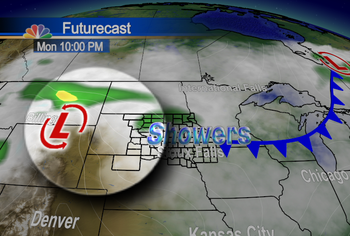
We highlighted the low pressure system centered just to the west of South Dakota. You can see we'll be seeing some light showers moving through - but the bulk of the rain takes a while to build in.

We step ahead to the next stage, with the bulk of the storm system and its associated rainfall highlighted:

As of now, while we are looking for some lingering patches of rain during the day Tuesday, and again during the day on Wednesday, most of the rain for eastern South Dakota into SW Minnesota and NW Iowa will hold off until Tuesday evening into the overnight hours.

Stay tuned over the next 24 hours - and know that despite the fact that it is raining, at least we're avoiding snow for this one!

~KDLT Chief Meteorologist Aaron Shaffer


Sunday, October 18, 2009

Did Someone Turn On The Heater?

Man, you have to love seeing this map after the COLDEST start to October on record, I sure do! Temperatures were 10-20 degrees warmer today than they were yesterday - even in the West - this is just a snapshot of the 24 hour temp change at the moment - earlier today everyone was at least 10 degrees warmer than we were yesterday - it's times like this where I wish we had a 48 hour temperature change because that would be incredible with the all the cold weather we had last week.

And 80s in October? Jealous of folks in Winner and Valentine - not that I can complain about 60s on the eastern side of the state after last week, especially since folks in the East will see similar temperatures tomorrow - though it will be cooler in the West and in the North. Winds will switch from the South to the North ushering in cooler weather.

Enjoy the peaks of sunshine tomorrow!

~KDLT Meteorologist Jesse Ritka

Saturday, October 17, 2009

SUN!!!!

Wow - it's been WAY too long since we've seen the sun! Too many days of rain and clouds for me - those added to the coldest start on record that Aaron wrote about yesterday. And I'm just so excited to see the sunshine again - I can't blog about anything else in the weather department today! Finally temperatures reaching up to where they should be this time of year and many places will actually have ABOVE normal temperatures! We haven't seen the southerly winds for awhile, so as they have returned, we're going to be seeing that warm air advection we've talked about a few times on here. Even tonight the southerly winds are keeping us warmer than the past few nights even though we're seeing clear skies. As much as the winds will help us stay warm tomorrow... it will get a bit breezy in the East, so keep that in mind as you plan your outdoor activities. And if you miss that pheasant while you're hunting tomorrow - blame it on the wind ;)

Enjoy the warm up!
~KDLT Meteorologist Jesse Ritka

Friday, October 16, 2009

Record Cold Start To October

We found an interesting news headline on the Sioux Falls National Weather Service office. It talked about a record cold start to October. Most of us probably figured it was somewhere near that, but it has been confirmed. So far, including yesterday, the average has been bumped up to 40.97 degrees.


Here is how things stack up for Sioux Falls, Huron, and Sioux City:


The big stats, to me, although Sioux Falls is pretty imressive with the coldest start ever... are in Huron and Sioux City. Both of them are breaking records set all the way back in 1925! Thankfully we have a much better start to the pheasant hunting opener.

~KDLT Chief Meteorologist Aaron Shaffer

Thursday, October 15, 2009

Finally Some Clearing... And More On The Weekend Warm-Up

Things sure have been nasty out there lately. If you are from the Pacific Northwest you are probably feeling right at home - but most people, like myself, are looking for some warmer weather and some more sunshine.


It is coming! That is the good news. Watch this movie below, showing our Futurecast model through Saturday:


You can see that nice clearing by the end of the movie. The next big question is about the temperatures. Cody talked a bit about the 850mb temperatures, which are one of our big gauges of just how warm things could possibly become. You should definitely read his post, and also check out this image below of just how warm some of the other computer models are looking for things to get as we head toward Sunday and Monday:

See those 60s and 70s to the West? They'll be headed at least close to us. Don't get too excited about these temperatures just yet - because right now they seem very optimistic. Upper 50s to lower 60s in our viewing area do seem likely, however. That will be a good change from what we've seen lately!

~KDLT Chief Meteorologist Aaron Shaffer

Wednesday, October 14, 2009

More Wet Weather

Looks like more rain and snow is in the forecast for later on today and tonight. Seems like we have had a really tough time shaking the chilly and wet weather out of here recently. But unfortunately today and tomorrow look no different. Precipitation looks to be pretty widespread across the area with many spots picking up .10-.50 inches of rain and even an inch or two of snow is possible in northeastern South Dakota later on tonight. To give you an idea of the timing and coverage of some of the precipitation, I added a link below that will take you to one of the models that gives you a prediction of what the radar will look like over the next 24 hours. Just click on the link below and then under the left hand column, click on the loop link underneath the title "Simulated Radar Reflectivity." This will give you a great idea of what we are expecting.


But the good news is it does look like sunshine and warmer weather will be here for your weekend. Still might be a little chilly for your Saturday but Sunday looks like a tropical heatwave...... ok, not really. But compared to where we have been recently, it does look quite warm.

Saturday Afternoon 850mb Temperatures (Celsius):
Sunday Afternoon 850mb Temperatures (Celsius):So just get through the next couple of days and there will be a nice reward for you provided by mother nature for the weekend.

~KDLT Meteorologist Cody Matz

Tuesday, October 13, 2009


Things sure are looking winter-like over the past few days. We tallied up some of the interesting weather statistics related to snow we could find, and check these out:


  • Mitchell has seen 0.9" so far this year, it took until November 6th 2008 to reach that total


  • Huron has seen 1.9" so far this year, it took until November 7th 2008 to reach that total


  • Sioux Falls has seen 3.5" so far this year, it took until December 2nd 2008 to reach that total


Pretty impressive stuff, huh? You can see in the map below what our futurecast computer model is thinking we're looking at overnight tonight into tomorrow:


You can see why in a view of the jetstream winds. Look at this image below, and know that the jetstream is basically like a river of wind in the upper levels of the atmosphere.


What's been happening is storms are taking the easy path - and hitching a ride along the jetstream. They've been sent off of a huge storm causing flooding in parts of California, and they ride the jetstream right over into the Sioux Empire.

Stay warm and have a good night!

~KDLT Chief Meteorologist Aaron Shaffer

Monday, October 12, 2009

More Snow On The Way? A Weekend Warm-Up?

It's been very winter-like outside over the past few days. In Sioux Falls we picked up 1.3 to 2.1 inches of snow during our latest snowstorm.


With another storm on the way, you are probably wondering, "Are we going to get more snow?" The answer to that is most likely, yes.


Looking at the video clip above of our Futurecast computer model about sums up what we're looking at. At the surface we will likely be at or near the freezing mark. Just a little bit above the surface we see temperatures dip below freezing. That shows us that we are looking for some possible melting of the snow, to fall in the form of rain - but most likely it will be snow. With how close the temperature difference is, you will likely want to stay tuned to KDLT News over the next 24 hours to see just what exactly is going to happen.


As for the future - we are seeing some nice warming potential come about the weekend:

Look at that image above. It is a computer model forecast for Sunday's highs. Look at those 60s on the map in yellow! Look at how close those 70s in the light orange-yellow color get to the rest of us! Could be a warm-up in our future...

Have a good night!

~Chief Meteorologist Aaron Shaffer

Could an Unsettled Week Lead to More Snow??

Snow falling across many areas as I write this but snow is about to taper off in the Sioux Falls area making way for just some flurries for the remainder of the morning. But the 7 day forecast points to a couple more storms that will pass through South Dakota over the next couple of days. So the question remains; will they be snow makers? Well, the answer is complicated. However, to simplify things a little I would say some of us will probably get some more snow. But the next couple of systems are looking far warmer then are current one. The image below points toward our next system that we are expecting Tuesday afternoon. It shows the probability of seeing rain vs. snow. Notice that it looks like rain will encompass much of the south while snow may be the predominant precipitation type across the north. So it doesn't look like "the big" storm is coming, (in terms of snow) it still looks like a possibility for some of us.

~KDLT Meteorologist Cody Matz

Sunday, October 11, 2009

Snowy October... With More Falling Tonight

Another snowstorm in the works for tonight to tomorrow. Take a look at this map below, our Futurecast computer model's thoughts on this current storm. The things to take from this are A) the length of time we see snow in the area and B) the little blurb that shows up near the end of the system. Most of us will see about 1-3" of snowfall from this system, with light accumulations on and off through about noon tomorrow.

Things sure are looking winter-like outside. Look at this video we shot from our KDLT Skycam as snow started to show up in the area:

Hard to believe that this is early fall still - and not late fall or early winter. Our average first day of 1" or more of snow in Sioux Falls is November 17th. We got 1.4" of snow on Friday, October 9th. That makes it the earliest 1 inch or more of snow we've seen since October 1st, 1999. Over ten years!

Stay warm & safe, and have a good Sunday night!

~KDLT Chief Meteorologist Aaron Shaffer

Friday, October 9, 2009

More Snow Pictures

We've been seeing snow start up in the Sioux Falls area at our KDLT station - but we've heard reports of some very heavy quick snowfall to our north. Our weekend director called in while duck hunting in near Montrose to say there were blizzard-like conditions, and Mark Ovenden told us about some heavy snow near Brookings as well.

We've had some good viewer pictures sent in to us today as well... this one and the next are from Carole in Houghton, SD:


Make sure you send us your viewer pictures to weather@kdlt.com or to me directly at a_shaffer@kdlt.com - and drive safely out there tonight and tomorrow morning. Also stay tuned as we head toward Sunday because there is some more messy precipitation on the way.

~KDLT Chief Meteorologist Aaron Shaffer

Snow On The Way

Well... for better or for worse - we are seeing snow on the way. Thanks to a loyal viewer in Pierre that often provides us with video we can get our first glimpses of snowfall in that area. This first one is showing the sleet that preceded the snow:


Then we switched over to the snow in the Pierre area:


That was a picture - but Zach from Pierre also sent us a video of the snow as well:


We are looking for around 1 inch of snow toward most of eastern and northeastern portions of our viewing area, with closer to 1-2 inches of snow farther toward the South. See Cody's post below for a fairly similar snowfall forecast to what I am looking for as well.

Have a good weekend and stay warm!

~KDLT Chief Meteorologist Aaron Shaffer

Here Comes The Snow

Looks like some light snow is on its way as it now looks likely that many areas will see the flakes fly later on tonight. the cold front that will be responsible for that snow is already pushing into western South Dakota as I write this. Notice the winds behind the front are gusty from the northwest.These winds will make Saturday feel that much colder and that is something we don't need as temperatures are going to be running nearly 30 degrees below average. The snow should accumulate in some areas tonight into Saturday morning with the best chances across the southeast. Here are the predictions for total snowfall from the National Weather Service.
Roads should be ok for the most part because the ground temperature is just too warm for snow to accumulate on the roads. But be careful anyway tonight because the roads will still be wet and slick.

~KDLT Meteorologist Cody Matz

Thursday, October 8, 2009

Snow In The Forecast? Preliminary Snowfall Forecast


As much as we hate to do it - we've started trying to figure out how much snow we're going to get. If you read through Cody's post below, and my post below that - you can start to see some trends showing up... namely, that we are looking for snow still. It seems likely at this point, so we posted a forecast from our Futurecast computer model.


Remember that this could still easily change prior to snow falling - but for now this is kind of what we're thinking. The scary part if you're not a fan of snow? We would likely *raise* the forecast snowfall totals if we were to change them.


Have a good night & stay tuned to KDLT!


~KDLT Chief Meteorologist Aaron Shaffer

Much Colder But Snow???

For those of you who don't like the cold weather, then you are going to have a tough time with the forecast because some much colder weather is on the way. A cold front pushed through the area on Wednesday afternoon which will cool many highs into the 40's today. But an arctic plunge of air will be heading this way for the weekend. Check out how cold it is by the images below.
Thursday Afternoon:
Friday Afternoon: Saturday Afternoon: Notice the dramatic shift in winds and cold air plunging in on Friday and Saturday. Accompanying that cold air could even be a little bit of snow as Aaron talked about yesterday. The chances for some snow showers are looking better and better every minute, especially for the southeast. Below shows the probability of seeing at least 1 inch of snow from 1am-1pm on Saturday. Many areas of the southeast have upwards of a 40 percent chance. So it looks like the first flakes of the season will be flying for some of us this weekend. Stay warm!!
~KDLT Meteorologist Cody Matz

Tuesday, October 6, 2009

Snow In The Forecast?

We're watching this next system for a couple of days now - and it seems like it's finally time to break the news: we might see our first snowflakes of the season fall late Thursday into the very early hours of Friday.


Look at this image below:


You can see two areas circled in light blue on that timeline. Look between Friday at 4am and Thursday at 4pm... that is where we could see our first chance for flurries mixing in with lingering rain showers. The big question is just how much punch is left in that system by that point? Right now it doesn't look like a whole lot - but just for kicks we will show you what one computer model is thinking about snowfall potentials (we are not forecasting this much snow as of yet):

Not a good-looking forecast for early October... hopefully things change - and if not, hopefully they at least do not look anything near what we are seeing in that computer model forecast above.

Have a good night!

~KDLT Chief Meteorologist Aaron Shaffer


Cold Weekend Ahead!!!

Temperatures have been chilly the last few days or so as highs remained from the upper 40's to the upper 50's. But overnight lows have remained, for the most part, above freezing. But it looks like that is going to change as some very cold air will be making its way down from Canada by the weekend. It will likely take a day though as we are looking at high temperatures for tomorrow will be back to average. But then, According to many forecasting models (one of them seen below) temperatures could top out in the 30's and bottom out in the teens in some places. Those temperatures are some 30 degrees below average.

850mb Temperatures Wednesday Afternoon:
850mb Temperatures Saturday Afternoon850mb Temperatures Sunday Afternoon:Even the Climate Prediction Center agrees. They have encircled an area that they are expecting temperatures to be well below average from the 8th to the 12th.Enjoy the brief warm up tomorrow....... while it lasts!!

~KDLT Meteorologist Cody Matz