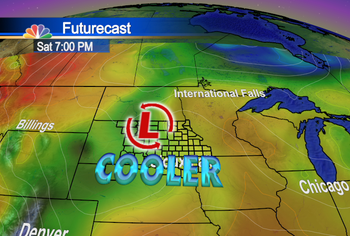
We have some new tools in our KDLT Weather Center - some of which you've seen, and some of which you'll see eventually. In this post we kind of combine both - and made 2 versions of our Futurecast map using the same lows and fronts but with one showing rainfall & clouds, and one showing future temperatures...
This is what we are looking at

You can see the rain overhead Friday night - and that is after a few little batches throughout the day. Look at this map showing temperatures, then, for Saturday night:

Right now we're still looking for lower 70s for the most part on Saturday - and some areas struggling to reach the upper 60s farther toward the West.
Have a good night!
~KDLT Chief Meteorologist Aaron Shaffer

No comments:
Post a Comment
Thoughts from you guys...